 Park & Permit Info
Permits are required for backcountry camping in Woodland Caribou Provincial Park. Ontario Parks notes that all fees collected by the park are used exclusively by Ontario Parks. Permits are also required for day-use and for frequent visitors to the park.
Permit and Fee information [pdf]
Permits can be obtained from:
(1) NEW – online permitting now available: https://reservations.ontarioparks.com/backcountry
(2) local canoe outfitters
(3) by mail from Woodland Caribou Provincial Park (P.O. Box 5003, Red Lake, Ontario, P0V 2M0)
(4) by phone via Point-of-Sale Service from the Ontario Parks office during business hours (Visa, Master Card, Tel: (807) 727 1329
(5) over the counter from the Ontario Parks office in Red Lake during business hours (8:30am to 4:30pm, Monday through Friday)
(6) from the self-serve station located outside the Ontario Park office
Road and Canoe Route Conditions:
 Fire Information
Campfires are allowed in the park as a rule. At times, however, areas within the park may operate under fire restrictions. In these situations, portable stoves, which are recommended at all times, are required for cooking. You can monitor fire conditions in the area via the Ontario Ministry of Natural Resources Current Fire Situation website.
Ontario Ministry of Natural Resources: Aviation and Forest Fire Management
 Maps & Routes
The available maps for Woodland Caribou Provincial Park present a trade-off: The small scale 1 x 50,000 Canadian topographic maps offer lots of detail except for showing very few of the portages. The official, larger scale park map shows less of the area’s detail–and no topographical information–but does mark the park’s portages. (You can always pack both!) The official map includes lots of interesting information on its reverse side – including information on the geology and ecology as well as an inset map depicting recent forest fires.
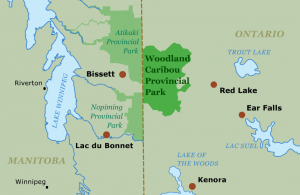
Like its wilderness cousin Quetico Provincial Park (Ontario), and its sister the neighboring Atitkaki Provincial Park (Manitoba), Woodland Caribou’s interconnected lakes and rivers offer myriad routes to paddle.
Suggested Canoe Route:
One basic, week-long loop that doesn’t require a fly-in starts from Leano Lake in the southeastern corner of the park. The put-in is at the end of Mile 51 Road, off of Longlegged Road. From Leano, paddlers will navigate a longer or shorter loop to the west that includes Lunch, Burnt Rock, Mexican Hat, and Glen Lakes. At Wrist Lake, trippers short on time and energy (or just interested in a more leisurely paddle) can begin the loop back through Aegean. Those wanting to put more paddling and portaging in can continue west from Wrist to Jigsaw, Haven, and Adventure Lakes before turning back through Welkin Lake and Beamish Creek.
At South Aegean Lake the long and short loops reconnect for the return to the put-in via Paull, Elephant Head, and Boot Jack Lakes. Portages on the route are often of the typical 50 to 200 meter variety, although the route has an 800 meter-long carry between Burnt Rock and Mexican Hat Lake.
 History
The history of the Woodland Caribou region is painted on its walls in red ocher. Pictographs from the Ojibway occupation of the area in the centuries before European exploration decorate the rock cliffs of Woodland Caribou Park in unmatched fashion. The Bloodvein River, a Canadian Heritage River that flows through Woodland Caribou and adjacent Akikaki Provincial Park in Manitoba is known not only for its whitewater, but also its pictographs and archaeological sites.
 Ecology
Woodland Caribou Provincial Park is located on a relatively flat granite plateau. A fault-line cuts through the 2.5 to 3 billion-year-old rock from Indian House Lake in the east to Wanipigow Creek in the west. North of the fault rocks are intrusive granites molded into smooth whaleback; south of the line the granites are rough and weathered and reflect volcanic intrusions. At Donald and Royd Lakes paddlers can see the shearing and fractures of the fault.
The climate in Woodland Caribou is hotter and drier than in the popular canoeing areas to the east. The dry climate, combined with Woodland Caribou’s well-drained plateau topography and its proximity to the western prairies creates a unique prairie-boreal ecosystem. Nearly 100 plants of the drier prairie habitats make a home in the park.
The park, as its name implies, also features a creature of the north–the woodland caribou. The park boasts the largest population of the shy ungulate south of the Hudson Bay lowlands.
 Fishing
Woodland Caribou features the classic northwoods three-some of fish species: lake trout, northern and walleye pike, and is known for its great fishing. White fish are commonly found in the deep lakes and fast moving waters of the rapids and waterfalls throughout the park. In addition, muskellunge, a fish reaching the northern limit of its range can be found in Irregular Lake at the southwestern end of the Woodland Caribou Park. Live bait is allowed within the park, but not recommended as the “cooperative” fish of the park seem happy to strike spoons and jigs. Anglers are required to hold an Ontario fishing license.


